Site Development and Utilities in Brownsville
More than 7,400 residences and businesses in Cameron and Willacy counties had minor to destructive flood damage in the June 2018 flood, and public infrastructure losses reached at least $50 million, according to the National Weather Service. Those numbers are not about any one building. They are about what happens when a flat county with slow-draining clay takes in more rain than its ditches, culverts and streets can carry. Site development is the work that decides whether your property is part of that story.
We handle the site side of construction: clearing, grading, fill, utilities, drainage, paving and the underground infrastructure that makes a building usable. For a new commercial project, it is often the biggest line in the budget and the biggest source of surprises. Done well, the site is invisible, because the water goes where it is supposed to go, the utilities connect and the pavement lasts.
What follows is how we plan and build that work in Brownsville and the communities around it.
Flat ground, clay and rain
Brownsville sits about 33 feet above sea level on soils that are mostly clay to silty clay loam, and a reference article says that several parts of the city carry a high risk of localized flooding because of flat topography, low-permeability soils and limited infrastructure funding. In June 2018, the National Weather Service reported that downtown, west and northwest Brownsville flooded on June 20, with six water rescues. In Los Fresnos, gauges recorded 14.49 and 14.09 inches of rain, several neighborhoods had a foot or more of water, and some poorly drained spots and open fields had three feet or more.
Our approach assumes that water will come and that the site must handle it. We start with a survey, a geotechnical report and a drainage study. We then set finished floor and pad elevations, shape the grading so water moves away from buildings, size inlets, pipes and detention to the engineer's design, and confirm that there is a legal place for the water to go. A site that sends water onto a neighbor is a legal problem as well as an engineering one.
What site development includes
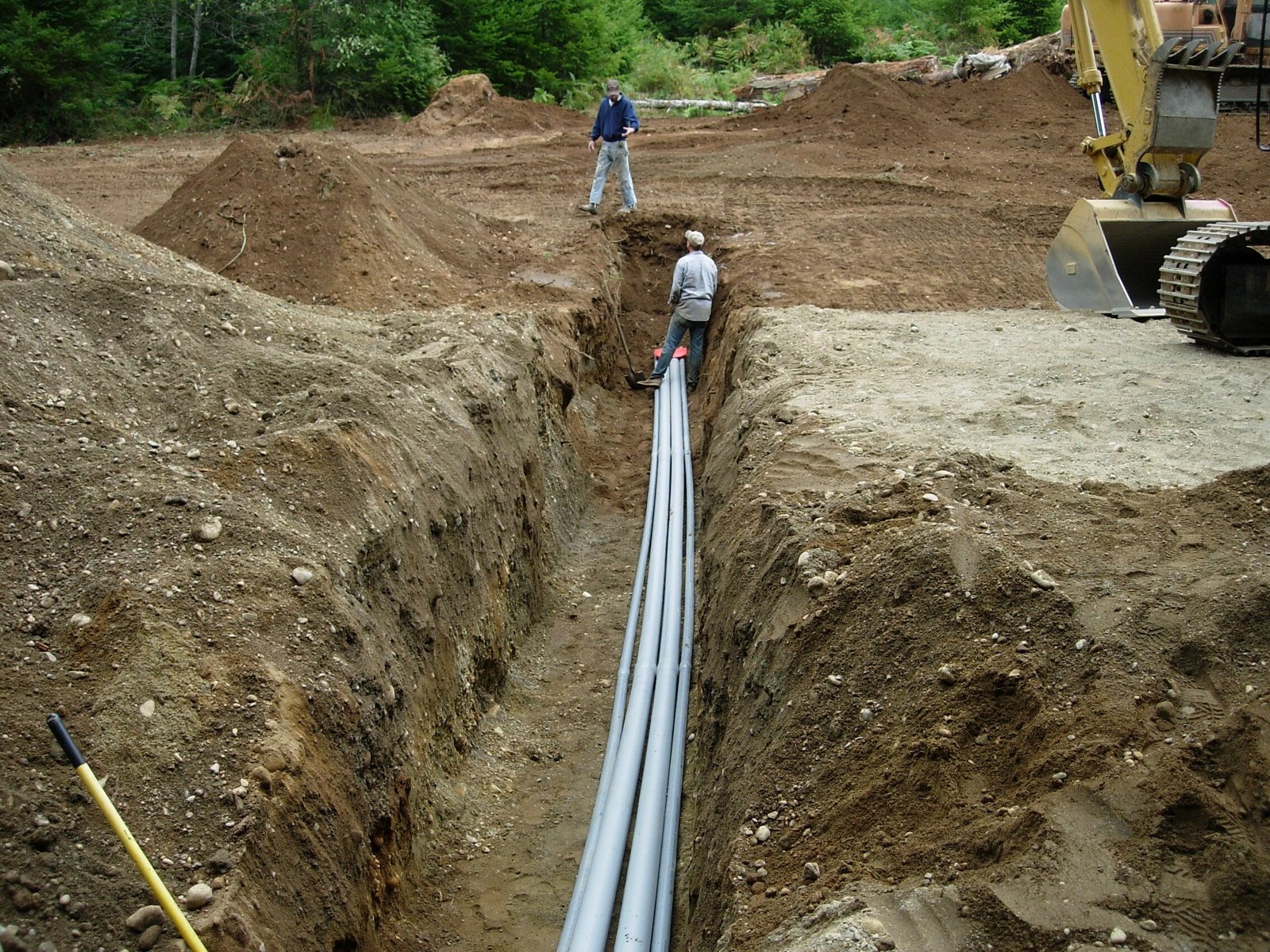
The work begins with clearing, stripping and proof-rolling, followed by cut and fill to reach design grades. We bring select fill where the engineer requires it, condition clay so it can be compacted and build working platforms for equipment. Utilities follow, including water, sanitary sewer, storm drainage, electrical and communications conduits, gas and fire lines. Each system is installed to the engineer's design and inspected by the utility or city.
Paving finishes the site: drive aisles, parking, truck courts, curbs, sidewalks and accessible routes. The trade partners for mass grading prepare the large areas, the trade partners for stormwater and drainage build the detention and conveyance systems, and the trade partners for parking lot construction finish the surface. Landscaping, fencing, lighting and signage close out the scope.
Coordinating site work with the structure
Site work and building work are linked. A building pad that is poorly compacted can settle, a utility line placed in the wrong spot can force a foundation redesign, and a drainage outlet that is a few inches too high can leave a lot ponded. We coordinate grading, utilities, paving and structural trade partners against shared survey controls, inspection requirements and documented handoffs so each scope uses the same levels and layout information.
Weather protection is included in the trade coordination plan. When rain is forecast, the affected trade partners agree how to protect open excavations, cover stockpiles and shape the site to drain. Utility conflicts are logged and referred to the engineer and utility provider as required before a layout or grade is changed. The look-ahead records the resulting inspection holds and revised handoffs, which matter in a rainy, hurricane-prone climate.
County rules, floodplains and utility approvals
Cameron County's flood regulations apply in all unincorporated areas of the county, name the County Engineer as Floodplain Administrator, adopt the Flood Insurance Study dated February 16, 2018, and require the lowest finished floor in a flood prone area to be 12 inches above Base Flood Elevation or 24 inches above the highest adjacent natural grade, whichever is higher. Inside a city, the city's own rules and drainage criteria apply, and the code edition varies by municipality, so we confirm them before design is final.
Utility approvals take time. Water, sewer, electric and fire marshal reviews each have their own schedule, and each can affect the others. We submit early, track comments and coordinate with the design team so that approvals arrive in the order we need them. Projects costing $50,000 or more are also registered for accessibility review, and we plan the route and parking details with that in mind.
Places with their own water problems
Every community in the area has its own pattern. The Town of Rancho Viejo's build-here page points to winding resacas as a feature of the town, and development near a resaca means setbacks, bank stabilization and careful outfall design. In Los Fresnos, the 2018 and 2020 storm reports show repeated street flooding, and a new project needs to be well above it. In Rancho Viejo and Port Isabel, the details differ again.
Port Isabel is a good example of coastal drainage. The Port Isabel-South Padre Press reported in July 2020 that, after Hurricane Hanna, Port Road in Port Isabel was submerged. Low ground, tidal influence and a high water table make drainage design there a different problem from the same work inland. We explain these differences to commercial real estate developers before they close on land.
Walk the site with us
Share the survey, the parcel and the use you have in mind. We will tell you what the ground and the water will ask of the project.
Questions Owners Ask
How much fill will my site need?
It depends on the existing grade, the flood requirements and the drainage design. The survey and engineer's plan give a quantity, and we price it with the geotechnical report in hand.
Do I need detention on my property?
Often yes, if the project adds enough paved or roof area. The city or county sets the criteria, and the civil engineer designs it. We build it to plan.
Can I build during the rainy season?
Yes, with planning. We protect excavations, stage work in smaller areas and keep the site graded to drain. Heavy storms may still cause delays, and we carry weather allowances.
What causes the most cost surprises?
Unsuitable soil, high water, utility conflicts and offsite requirements from the city or utility. Early surveys and borings reduce them.
Who owns the drainage after construction?
It depends on the design and the approvals. Some systems are private and maintained by the owner, others are dedicated to the city or district. We confirm it in the permit documents.
Related
Related Services
Related Service Areas
Ready to talk about your project?
Request a Project Review
Planning a build in Brownsville or Cameron County?
Share the site, the building and the schedule. We will walk the drainage, soils and permit path with you and follow up with next steps.